| Client | AFD |
| Period | Aug. 2013 - Dec. 2014 |
| Location | East Java |
| Partner | FRM |
| Sectors | Forestry |
| Focus Area |
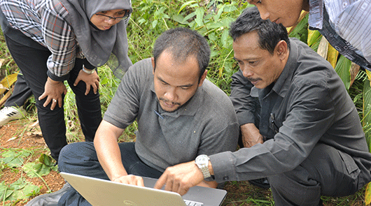
Daemeter engaged local communities in East Java on a community mapping exercise, including training in the use of GPS and survey techniques, as part of a long-term project to encourage community forestry with AFD.
Daemeter conducted a community mapping exercise in East Java on a total area of 450 hectares that include 1,300 smallholders’ forest blocks. This assignment was part of a long-term project to encourage community forestry with Agence Française de Développement (AFD).
The work involved a pre-survey, in which Daemeter surveyed a number of the areas included in the scope of work to determine the possibilities of mapping such a large number of fragmented forest blocks. After this exercise, with the assistance of the village head, local forestry association and local forestry agency, Daemeter engaged the local communities to assist and participate in mapping the areas. As many as 20 people living in the local villages were trained in the use of GPS and survey techniques. This survey team walked the boundaries alongside the owner of the trees to collate and check data on the ground.
The large dataset was then compiled into a GIS database to form a basic GIS-linked forest resource description of the area, which will assist with subsequent certification as well as leveraging further investment in forestry in the region.